
Frequently Asked Questions
Our Cyclone Center talk page is a great resource for users to engage in discussion about particular images, as well as get some feedback from moderators and the science team. If you haven’t seen it yet, we suggest checking it out!
Since our launch, we have received a lot of feedback and questions about the project, through members posting on our talk page, as well as comments on this blog. Thank you very much and keep them coming! We have put together a FAQ that we hope will answer many of your burning questions:
FAQ’s:
How do I pick the right match?
Focus on the shapes of the clouds and their colors. Size and orientation don’t really matter. The key is remembering that tighter spirals and colder colors are signs of stronger storms. It’s a little subjective, and that’s why we’re doing this. Your opinion matters, so give us your best guess.
If it’s subjective, then what’s the point?
When two opinions about a storm are different, we need to determine which one is best. Cyclone Center has up to 30 volunteers look at each image, and then we’ll combine them statistically. This approach has worked well in other citizen science projects. It’s never been tried with tropical cyclones before, but we are confident that your classifications will help us learn more about these storms.
Hasn’t an expert already looked at these storms?
Yes, but the methods have changed over time and between regions. We have nearly 300,000 satellite images of tropical cyclones for the last 32 years from around the world. You’re helping us classify all of them with one method. You’re also providing us with valuable new information about the shape of the storm, like whether or not it had an eye. It would take a team of experts years to finish this task, so we’re relying on you to help us do it much faster.
Can a regular person like me really help?
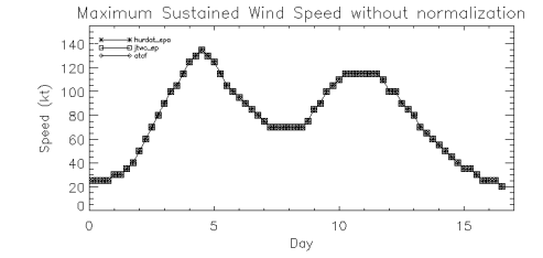
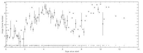
Yes!! We even have some preliminary data that tells us how great you’re all doing. The two graphs here show the current estimate of intensity for a particular storm (top), and the estimate that we’ve gotten from your classifications (bottom). We are just starting this project, so there is more analysis to be done. But it’s clear that your classifications are matching what we expected! You can find more information on our blog here.
What’s a Cyclone?
The dictionary says a cyclone is a storm that rotates around a center of low atmospheric pressure. That can include tornadoes, winter storms, and the “tropical cyclones” that we’re looking at here. Tropical cyclones are organized systems of thunderstorms that get their energy from warm tropical oceans. They’re often called Hurricanes in the Western Hemisphere, Typhoons in the western North Pacific, or just Cyclones in the rest of the world, but they all mean the same thing.
This doesn’t look like a hurricane. Where’s the eye?
When you think of tropical cyclones, you probably picture the classic circular storm with a clear eye in the middle. However, eyes only happen in stronger storms, like the ones that make the news. We think about 15% of our images will have those picturesque eyes. Most of the others will be less organized and harder to classify. In fact, because they’re more difficult, those weaker ones are where we need the most help and you can make the biggest difference!
Are there only these six images for this storm?
Probably not. Because the images are collected every three hours, and most storms last several days, a storm may have several hundred images that cover its whole life. In fact, Tropical Cyclone Hondo lasted nearly all of February 2008 and has over 600 images!
You are seeing six images taken from some period within the storm’s life. So in most cases, you’ll see a portion of the storm’s life cycle, but not the entire thing.
What do I pick when it doesn’t look like anything?
If it looks like there is no organized storm in the image, try looking through the curved band options. Curved bands are generally the weakest of the storm types, and often appear very disorganized. However, from time to time there is an error in the satellite location, and there might truly be nothing in the image. If that’s the case, choose “No Storm” under the “Other” option.
I made a mistake! How do I go back?!
If you’ve already finished the image, don’t worry! There’s more than one way to classify most of these images. By averaging all your answers together, we’ll still get a pretty good estimate.
If you haven’t completed the classification, you can always go back to the beginning and start that image over. In the bottom right corner, next to the Detailed Classification checkbox, you should see a small orange arrow. Clicking it will take you back to the beginning of that image.

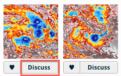
I found a neat storm. Can I talk about it or save it for later?
After you’ve finished a set of images, you’ll be shown all 6 of them side by side, and each one will have a “Discuss” button beneath it. Simply click on that button, and you’ll be taken to our Talk page, where you can post your comments about that image.
Alternatively, you can always go to talk.cyclonecenter.org and see what other people are discussing, or start your own conversation about anything that interests you!
If you’d like to save an image for later, just click the heart next to the “Discuss” button, and the image will be saved to your favorites.
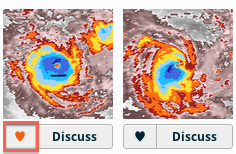
To get to your favorite images, click the “Profile” button at the top of the page. You’ll be shown how many images you’ve classified, and here is where you will see the list of all of your favorite images. From there, you can quickly get to the “Talk” page, where you can discuss that image.

Is there any other way I can help?
Yes! When it comes to citizen science, strength in numbers is our greatest asset, so recruit some friends! You can like us on Facebook at facebook.com/cyclonecenter or follow us on Twitter at @CycloneCenter. The more classifications we get, the better the science will be in the end!
When Tropical Cyclones Die

Davina (1999)
All tropical cyclones die. Sometimes they move over land, sometimes they move over cold water, and sometimes the atmosphere becomes too fierce and rips the storms apart vertically. In this interesting image, highlighted by one of our Cyclone Center collaborators, Tropical Cyclone Davina (1999) appears to have suffered from a combination of these factors. Once a powerful 120 kt. storm, she is now just a pathetic shell of her former self, a swirl of low-level clouds with weak thunderstorms ripped away to her southeast.
Our classifier wasn’t sure how to categorize this storm – what do you think? To learn more, go to Cyclone Center.
– Chris Hennon is part of the Cyclone Center Science Team and Associate Professor of Atmospheric Sciences at the University of North Carolina at Asheville
Super-preliminary-barely-ready-for-the-public results look promising!
Well, after getting 100,000+ classifications, we thought it was time to let you – the citizen scientists – know that you’re doing a great job!
Q: What did you find?
A: During our preliminary analysis, we have observed some results that encouraged us – the science team – so we thought it would encourage you – the citizen scientists. Read More…
Tales from the road… AGU Fall Meeting
CycloneCenter.org was presented for the first time today at a major scientific meeting. This was the Fall Meeting for the American Geophysical Union (AGU), a gathering of over 20,000 scientists in San Francisco. The talk was in a session devoted to research by Citizen Scientists like you!
 A lot of other scientists were excited about the potential this Cyclone Center has. Together we’ll be able to answer some important questions about the climatology of tropical cyclones. And along the way, we get to interact with you! We also got some great suggestions on how we, the Science Team, can make it easier for you to interact with us. So keep a lookout for some big things we’ll be trying in the coming weeks!
Thank you for all your hard work on Cyclone Center and keep it up!
2012 Atlantic Hurricane Season: Signed, Sealed, Delivered

The motto that isn’t really a motto
The United States Postal Service (USPS) has been delivering mail for over 200 years (and recently, losing a lot of money doing it). Their motto, which apparently is not their official motto at all (just branded all over their NYC postal building) is well known: “Neither snow nor rain nor heat nor gloom of night stays these couriers from the swift completion of their appointed rounds”. Notably missing from this statement is “hurricane”, “superstorm”, or “storm hybrid” – Hurricane Sandy showed that it is not possible to deliver mail when a good portion of your city is underwater.
Last Friday the Atlantic tropical season officially ended. There isn’t a switch that gets turned off that prevents tropical cyclones from developing after November 30; in fact, we have seen storms form into January as recently as 2005. Nevertheless it is beneficial to designate a tropical cyclone season; it gets people’s attention and does have some scientific merit. The great majority of storms do form between June 1 and November 30, and storms that do form outside those times rarely affect the U.S.
Of course in other parts of the world the tropical cyclone seasons may be just beginning. The conditions that allow for their formation in the northern hemisphere late summer/early autumn (warm ocean waters, favorable atmospheric conditions) are just now setting up as the season turns toward summer in the southern hemisphere. In the tropical western Pacific, where more tropical cyclones form than any other basin, conditions are so favorable that storms can form year round.
For Americans, the 2012 tropical cyclone season will be remembered by one name – Sandy. But it was quite an active season as well, with 19 storms becoming strong enough to earn a name. This movie shows many of these storms:
Of those 19, only a handful were directly sampled with reconnaissance aircraft; for the rest, as well as storms in every other part of the world, their intensity were estimated primarily from the Dvorak technique. Cyclone Center citizen scientists use a similar technique to classify historical tropical cyclones – one day Hurricane Sandy will be one of those that users will classify.
We launched the project back in September and it’s had more than 100,000 classifications so far. Cyclone Center is one of the most challenging projects ever built by the Zooniverse, but with each classification you’re contributing to our knowledge of tropical storms.
So far the Cyclone Center community has analyzed more than 500 storms as they raced across the globe. The weather data used on the site comes from 30 years of satellite images and so many memorable storms are being closely inspected by volunteers on the site each day: Katrina (2005), Andrew(1992) and Gilbert (1988) amongst them.
Interestingly, this is the 7th consecutive season that the U.S. was not impacted by a major (Category 3 or higher) hurricane – hard to believe after going through a storm like Sandy which technically may not have even been a hurricane as she came ashore. As storms continue to become stronger in a warmer climate and societal impacts become more severe, it will be more difficult for mail carriers to make their appointed rounds…assuming mail delivery isn’t cut to 1 day a week by then anyway.
– Chris Hennon is part of the Cyclone Center Science Team and Associate Professor of Atmospheric Sciences at the University of North Carolina at Asheville – this blog is part of the 2012 Zooniverse Advent Calendar.
